ค้นหาบล็อกนี้

วันพฤหัสบดีที่ 26 มกราคม พ.ศ. 2555

Lamphun


Lamphun
Lamphun often plays poor step-sister to Chiang Mai, just 26 kilometers away. Even though its older than Chiang Mai by about 500 years and is the capital of its own province, the town is generally only visited as a day trip from Chiang Mai. It is a small town, with some significant sights, but there really isn't much here to occupy you for more than a day.
Lamphun is one of Thailand's oldest continuously occupied towns. It was founded in 660 by Queen Chama Devi, the daughter of the King of Luovo (now known as Lopburi). She founded the Haripunjaya Kingdom, which became the most powerful Mon center in the North for hundreds of years. It wasn't until 1281 that the city finally came under the influence of the Lanna Kingdom founded by King Mengrai, who made Chiang Mai its capital.

Tourist attraction.

1)Wat Phra That Haripunjaya
is one of the most venerated temples in Thailand. The 50 meter tall gilded chedi in the center of the temple was started around 897, although the founding date for the temple is put around 1043.

2)Doi Khun Tan National Park
The mountains block boundaries. แmeta between Lamphun district. Hang Chat district, Lampang province in the center of transportation and railways. The Lampang - Lamphun Declared a national park on March 5, 2518 with a total area of ​​159,556 rai of Doi Khun Tan includes many features including evergreen forest and pine forest with four peaks of Doi's highest peak, to walk about 7 miles.

วันเสาร์ที่ 2 เมษายน พ.ศ. 2554

Chanthaburi

Chanthaburi
is a city of old historical evidence. Believed that at least 1,000 years old, created by Jean Some people say that myth created by the same cities as the nation Khmer stone inscription called "Kuan Craft Buri" natives called "sensitive urban check" as a parent. Chanthaburi same pool located in front of his sin. The original indigenous people live is called Chong has spoken their language. Unlike English and Khmer. You retain great cities is legendary. Lord Brahma Mrigadat (year 1349-1399) But the year 1800 have been migrated to a
new town houses Hua Wang Phung district, which is close to breaking macrofaunal today.

National Park flutter
District covers an area the city. Laem Sing district Khlung and tamarind. Chanthaburi Province. Includes a complete jungle. High mountains are a complex multi-line source watershed. Is the unique nature flutter beautiful waterfalls. Year-round waterfall. Well known to the general public. Which is located about 14 kilometers from Chanthaburi asphalt all calls made to the convenience of leisure travel. An area of ​​134.50 square kilometers or 84,062.50 rai.

Khao Khitchakut.
In the area of ​​forest Khitchakut or Khao Phra Bat. District tamarind District and he Khitchakut. Chanthaburi Province. Consists of the mountain. Views. The highest peak in the altitude of 1000 meters, with beautiful natural phenomena such as waterfalls, bison, and geology related to Buddhist legend. Especially in terms of religious belief about the Buddha's footprint on the mountain Khitchakut. An area of ​​58.31 square kilometers or 36,444.05 rai.

Chao Lao Beach,
Tha Mai district, located 17 kilometers away from the quiet. A creamy sand color. Long stretches of the eye. With tropical coconut trees. The popular ones to rest well this weekend.
Accommodation ranging from moderate to standard. And restaurants to serve tourists are also glass bottom boat and speed boat services to tourists to visit the shallow water coral reefs located just 2 miles from the coast only. This is something that is not easy to find. It usually happen in areas where coral island is only Because the flow of current good Right temperature and without pollution of coral reefs found near the coast are easily accessible to visit, which takes about 1 hour.

Market Thai - Cambodia (lettuce fields)
is located at Ban Khlong Yai, Moo 4, Tambon Klong Yai away from Pong Nam Ron District 30 miles to market consumer products. The relief is only allowed to travel to the Thai tourism between 07.00 - 16.00 pm This market is about 20 miles from city Pailin and Battambang miles from the town 68 km (shoppers do not miss the final Impact Impact.)

วันพุธที่ 30 มีนาคม พ.ศ. 2554

Trat

Trat Province
is a small top border of the east coast of Thailand. Assumed that the "Trad" Distortion of the word "random", which is the name of a type of tree used to make brooms and around Trat in the past, it was an early "random" is a lot more. But in the Ayutthaya period. The reign of King Naresuan "Trad" is the name at that time that "some of his home."

Rs 112 in the reign of King Rama V. Has a treaty with France. Cede territory, Koh Chang, Trat and from Laem Sing to Koh Kood. Including tropical city Pehhane Kiri (Koh Kong), to France. French troops to withdraw from Chanthaburi Later, on 23 March 2449 to cede territory, city, Siem Reap, Battambang and Srisophon including tropical city Pehhane Kiri to France in exchange for out of Trat islands from Laem Sing to the island. Kut. The town of Dan Sai right bank of the Mekong River during the night. The Thai authorities have possessed the great prince, Prince D Drug.
In that time, the prince told the Permanent Secretary Thep celebration. Ministry of Interior The chief representative of France with the Royal Thai Government Amoongsieoornt Bruce is the new X-Sim. Chief representative of the French government. Send a ceremony and have done the same award at City Hall. And France willing to withdraw troops away on 6 July 2450 Trat people have to fall on day 23 of each year as "Trad remember."

Koh Chang Thailand
is a Leisure Island least known to foreigners, the largest among the 52 islands of Trat, is also the nation’s second largest island, after Phuket. Koh Chang (Ko Chang) has always been a favorite get-away for Thai people. Its hinterland consists of over 70% virgin rainforest and is the best preserved but little known tourist destination in Thailand. Situated to the east of the country in the province of Trat on the Cambodian border, it’s Thailand’s second largest island after Phuket.

Pineapple Gulf.

Pier pineapple Next to the Dan Kao Pier to Pier One. Mail port. And ferries. The beginning of the Gulf of nature, and Laem-Trat is a starting point. Getting to Koh Chang of the Gulf beaches, pineapple rock. Unable to swim. These are important A deep water port. A mail boat and ferry boats to dock on a regular basis. Similar port of Nathon, Koh Samui, but much smaller. Docks buses look like a minibus. Parking shuttle tourists. In order to submit a resort. Accommodation and various By the beginning of the end of the Pier pineapple Kai Bae. Distance of 17 kilometers by a visit to the resort any time. Without notifying the driver know. A resort that will be agreed to or chartered vehicles. Take the trip around. Koh Chang, optional. Pineapple Gulf port area. Are available in cheap restaurants. Visitors can eat.

Klong Chao Waterfall.
Fun stream or waterfall.
The waterfall is in the name of Koh Kood. Water flow throughout the entire year on the third floor look like streams. The ground floor is a stream from the waterfall. The right to play a lot of water. Waterfall This waterfall is considered the historic King Rama VI. His trip was when the year 2454 he graciously signed for a memorial to Chiang Mai to Sue that "Waterfall Oneam Kingdoms."

White Sand Beach,
just behind the island elephant I came Klong Son beach is a long beach has clean white sand called White Beach Hotel on the majority. Accommodation is affordable beach has a good street tire sauce. Length parallel to the beach. Access to the beach the other night color light show of restaurants, pubs, wine has a small swimming along the beach. But be careful not to swim away from the beach much. Had it will gradually Gradient shallow depth to unequal Chucheep to wear swim far away from the beach and swimming in addition to. Visitors can rent a bike. Bike ride or play beach is the most beautiful sunset on one of the island.

วันอังคารที่ 29 มีนาคม พ.ศ. 2554

Narathiwat

Narathiwat Province
Is a province in southern Thailand The southernmost provinces of Thailand A march on Malaysia Located on the east coast of Peninsular. Away from Bangkok. Car about 1149 km with an area of ​​approximately 4,475.43 square kilometers, or contact the North farm 2,797,143.75 with Sai Buri district in Pattani Province, Mai Kaen district and the eastern Gulf of Thailand, contact the Gulf of Thailand and Kelantan. Malaysia Contact the South Kelantan. Malaysia West Contact Bannang Sata district of Yala province. Areas, mainly forests and mountains 2 / 3 of the total area. With about 361,860 rai of forest, swamp band southwest ridge mountains stretch Gal Kiri, a border along the Thai - Malaysia. Area characteristics are slope from west to east. Most of the lowland area adjacent to the Gulf of Thailand and the plains around the river is 4 lines Bang Nara River, Sai Buri River and Gold River, Tak Bai - Lok. It has a population of 717,366 people divided into 356,229 males 361,137 females, persons, Narathiwat centered economic, trade, investment and industry in the district of Sungai Ko - Lok. This is a district that is larger and has more growth than the province.

Thaksin Palace Palace.
Thaksin Palace Palace is a palace residence of His Majesty and Her Majesty the Queen.
With royalty His variation on the palace grounds to the southern provinces. During the months of August to October of each year. The Palace is situated on a hill along the Gulf of Thailand height above sea level, 173 feet by building a brick and concrete buildings Tืopoon. His style of modern Pan Ya. This is a popular art and architecture of the Southern people.

Narathiwat Central Mosque
was established as a place where Muslims in Narathiwat province,
which has many to pray together. The mosque was the central location, Narathiwat Road, Bangna, c achieved maintenance Muang district, Narathiwat. From Narathiwat town hall for about 2 miles to build on year 2424 with a budget allocated by the government with money and faith of the people, totaling 21 million, three hundred thousand baht, but the premises when the building is completed. selfishness Has had to buy land and build a new land head straight road maintenance achieved. Preda Bridge near the beach area of ​​10 rai 2 Nara vision tasks using a total budget of 35 square meters. 22,621,113.75 Baht

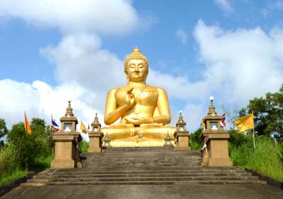
Mongkol Buddha Thaksin Ming.
Buddha sat sat together at a beautiful camp and sent.
Largest in the South. Created by Buddhist art technician south Indian currency (a boiled sweets) with a lap width of reinforced concrete 17 meters high from base to top the Kes 24 meters and decorated with colored mosaics from the whole body. And contains the relics of the initial left Oura.

Ao Manao.
A sandy beach next to the beautiful seaside mountain. Long beach stretch Bang Nara River. Right-side stretch zone Thaksin Palace Palace. Pine Beach Evergreen Line will find the beach.


Khao Budokan - Su-ngai Padi.
Covered with lush vegetation. The integrity of the forest. Larger trees at Nana Union.

Narathat beach.
White sandy beaches interspersed with lush Thewson. For the more adventurous. Exercise and fishing.

วันจันทร์ที่ 28 มีนาคม พ.ศ. 2554

YALA

YALA
Yala, a former region of Pattani. In the reign of King Rama V (King Rama 5) has been updated to the new rulers a rule Edsrpibre and has issued regulations for the government seven cities Sovereign era 120, which consists of Pattani, Nong Chik Yaring Sai Buri Yala Rangae and Raman in each city will be divided into Sub-District area and the village later in the year 2447 was declared in Pattani province care instead of the 7 provinces, Nakhon Si Thammarat province. And collapse the city to 4 cities including Sai Buri, Pattani, Yala and Rangae next year 2450 the city of Yala area, divided into 2 Muang District, including Yaha district, Yala and later Act 2475 has been canceled, and in Pattani province. Year 2476 has transformed the city of Yala Yala Province as the Kingdom of Siam Act BE 2476 on organizing regional administration. Into the district and province to province governor. And the Provincial Department of Public Administration.
Yala, a province of the Municipal Planning held a spider the most beautiful in Thailand. And won the contest three years in a row between the clean and BE 2528-2530 has been raised as Yala municipality in the year 2538 in the year 2540 was selected from World Health Organization is a 1 in 5 cities of Thailand in the project cities around the world.
Park Kwan Muang.
Yala city park. Away from the City Pillar Shrine 300 meters derived from the swamp park is a sports bar scoop and place of recreation of the inhabitants of the rock and an artificial beach. The stadium sound dove Java Prem Tinsulanonda came open Kwan Muang Park on July 21, 2529.
Bang Lang Dam.
Building blocks Tapi river at Ban Bang Lang, Bacho district,
Bannang Sata district. Away from the city along Yala Yala - Betong about 58 miles to the intersection of the dam at the 46 mile and turn right to another 12 miles to the dam dam built to prevent flooding, irrigation and power generation at the dam over the pavilion view. Overlooking.
Wat Na Tham
Measuring stand Pimuk (Wat Na Tham)

was Na Tham Muang Yala along - Hat Yai town 4 km away from the path to the Yaha district. Villagers commonly called Wat Tham page because the temple is a large cave with a large reclining Buddha of the ancient shrine inside. Assumed that the building since 1300 as the reclining Buddha Srivijaya period. Length 81 feet 1 inch, believed to be the same as Vishnu Banthom Sin Pang. Because the images cover the head snake cobra hood spread. Subsequently adapted to a Hinyan reclining Buddha. Reclining Buddha Wat Na Tham people of this southern sanctuary is considered a key territory in the southern third of the city Phra Nakhon Sri. Phra Chaiya at Surat Thani Reclining Buddha and Wat Na Tham.

วันเสาร์ที่ 26 มีนาคม พ.ศ. 2554

Mahasarakham

Mahasarakham

Muang Maha Sarakham is considered that the archaeological importance and long centuries. It has found archaeological evidence that has been influenced by Buddhism, since Gupta Ta upper and pump million Eya of India through the city Bagan in the form of art Dvaravati as the city Kantharawichai (Kok King) and the town Nakhon Champa Si. The evidence is Kantharawichai Yuen. Porapoiampot clay. Throughout the relics. In addition, it also was influenced by Brahmanism through ethnic Khmer. In a period such as Lop Buri Ku Santarat Khwao Ku Ku Ku house red and the other to include the Khmer pottery idol and the other to the ground surface around the Province.
King Rama VI was graciously pleased to address the "big rubber Lat Kut, a city in Maha Sarakham on 22 August 2408 in separate areas and about two thousand citizens from the city Roi Et And Whereas. Thao to Mahachai (tutorial that Phu DSpace pharmacist) as Rat King as Det ruler with Tao Buathong assistant in the town of Roi Et

Standingbuddhamongkol
Buddha Maha Sarakham city pairs. The district is Canharrnrษฎrnt. Kantharawichai. On Highway 213, about 14 km from downtown (right hand) Buddha Dvaravati. Built with red sandstone. Charming City like a Buddha. Buddha said that this second body. Is created at the same time. When Kantharawichai drought Men created the Buddha Ming city Women stand a sacred Buddha image. Done once and then make a huge celebration. Appear to have created from God and Buddha both rain must fall season. Cause the abundance of this great region.


Phrathatnadun
Buddhist of the Northeast. Located at Ban Na Dun. Dun district. Is a field that is excavated to a plethora of historical evidence. Archaeology shows that the prosperity of the past. Because this area has been the location of the City of Champa Si before. Various antiques. Found to be presented at the National Museum, Khon Kaen and the most important is excavated stupa containing relics housed in gold, silver and bronze bearings, which assumes that age in Years 13-15 Dvaravati. The Government has approved the operation. Phra That Na Dun construction. Area of ​​902 rai in the surrounding area. A museum of religious and cultural Arboretum Herb Garden, which furnished an important place in Buddhism. Travel to the city by Maha Sarakham Highway 2040 through Kae Dam. Wapi Pathum. Turn right onto Route 2045 to Dun district. The paved over. About 65 km away from downtown

วันพุธที่ 23 มีนาคม พ.ศ. 2554

Lopburi

Lopburi

Province in the central region. Is a province located in the center of the country. Fertile areas suitable for cultivation. Historic. Current location of troops and the Army and Air Force multi-unit Centered on the military. Of combat forces. Lopburi is a terrain that is located right in the middle of the country making it the center of the military, which can be spread or distributed workforce. Strategic Arms Master Pakorn to regions more easily and quickly.
After the change of government. Lopburi has been nurturing time again marshal Por Pibulsonggram. As a whole. In addition it has been planning a new military unit and set up in Lop Buri Lopburi is known, so it is a military town, because there is significant military units to 11 units is now Lopburi. City economy. Scenery town Education Center of Central Upper. It is also the city with soldiers, and also has an interesting attractions include the Pasak Chonlasit. Narai Palace Palace. Phra Prang Sam Yot, he parsed and Sunflower Field of the largest in the country. (With area up to. 200,000 to 300,000 rai) and was named a province with many monkeys lived. And that the province is receiving the attention of tourists, both Thai and foreigners. Traveling to the Lop Buri Province, a large number.


Pasak Chonlasid Dam. Lopburi Province.
Is located at Ban Kaeng Sua Ten dam Bua Commented Chonlasid is the name His Majesty for this dam. Under the Pa Sak River Basin Development Project. Due to His Majesty. A clay core dam in Thailand, the longest length of 4860 meters, 36.50 meters high at the peak of interest within the dam features include Viewpoint Dam. Pa Sak Basin Museum. This shows knowledge of the natural and cultural Pasak Chonlasid has officially inaugurated on November 25, 2542.


Sunflower Lopburi.

Sunflower Lopburi Province. Most sunflowers are grown in Thailand is about 200,000 to 300,000 rai sunflowers will bloom during the months of November to January sunflower plants are drought resistant. Farmers grow corn instead. Sunflower seeds are nutritious. Used to extract oil for cooking, drying or eating. Or used as an ingredient of cosmetics. You can also promote beekeeping as a career also. Enabling the production of sunflower honey is another way. The source of cultivated sunflower. Are scattered throughout the city district. Pattananikom District. Chai Badan. Area planted a lot of areas, including China, and then he. Near the temple Weluwan Kok Muang Tum.